Day 1: Going Hokkaido
After returning from our Mt Fuji climb the day before, today
we strapped our backpacks up and headed north to Hokkaido. We left our hotel
near the Yotsuya metro station, took the metro on the red line (Marunouchi
Line) to Shinjuku and changed to the pink line (Oedo Line) to the station of
Daimon. From there we walked a short distance to the JR Hamamatsucho station
which is connected to the Tokyo Monorail which took us to Haneda Airport. But
if you carry a lot of bulky luggage, it can be challenging if you taking the
metro like us and alighting at Daimon. Alternative way is to hop on the JR
Yamanote Line and alight at the JR Hamamatsucho
station. It takes about 20mins to reach Haneda Airport if you take the
Haneda Express train, and will be longer if you take the Rapid Train and even
longer on the Local Train. We took a JAL flight from Haneda to New Chitose
airport. There are many flights to Hokkaido, with majority of them flying into
New Chitose which is the nearest airport to Sapporo.
We landed around 1pm in the afternoon at New Chitose
Airport. We had booked a rental car as the means of transportation for us to get
around in Hokkaido. There are car rental counters at the airport, but you have
to collect the cars at another location close to the airport which the
individual car rental companies will provide shuttle bus service. We confirmed
our reservations at the counter and were told to board the bus. Japanese being
efficient in their operational aspect, radioed their colleague at the car
collection centre to prepare the paperwork for us. The journey from the airport
to the car collection centre was about 15mins drive away and you can see other
car rental companies all located in the same area. Big names like Toyota,
Honda, Mazda have their own car rental company. In the end was all about price
and car preference. There were 4 of us and all our bags, and we chose a Toyota
Felder 4WD for our self-drive trip in Hokkaido.
 |
| Our rented car for the entire Hokkaido trip |
Our first stop was Farm Tomita, located at Nakafurano. As of now (July 2012), there is another way
route as mentioned in Goggle map that goes by the way of highway 337, then
switches to the Doto Expressway until the Chuo interchange and then changes to
highway 237 to Nakafurano. But for us, it was the highway 36, then to 72 and up
the Hokkaido Expressway all the way till the Takikawa interchange and then
change to 38 all the way to Furano; and northwards on 237 to Nakafurano.
 |
| Wattsu Highway rest stop |
After
driving for just 30mins on the Hokkaido Expressway in the direction of Sapporo,
we stopped at the Wattsu rest stop (12:30pm) for snacks and bottled water stock
up for our self-drive trip in Hokkaido. I was always attracted by these
overseas highway rest stop to have a taste of the food the locals take.
 |
| Fried Food Vending Machine |
Even
thought this was our 3rd trip to Japan, it was the first time that we came
across a fried food vending machine. It
was not that we were hungry, but just wanted to see how it tastes. We ordered
some potato wedges and it came out not too bad for a vending machine. Japan is
not just the land of the rising sun, but the land of the unbeatable vending
machines. After grabbing the supplies we needed, we continued on the long
drive.
 |
| Buddhist Statue at Ashibetsu |
After taking the exit at Takikawa Interchange, we started
driving on mainly single lane road passing through Akabira and then to
Ashibetsu. We intended to continue our drive until we caught sight of a tall
white Buddhist statue that resembles the Goddess of Mercy. We drove into the
compound and took a few pictures near the big car park. Not sure if it was
closed as we couldn't see anyone people around except us.
 |
| Farm Tomita at Nakafurano |
 |
| Rows of coloured flowers |
Around 3:30pm, we
reached the Tomita Farm to see the nice flowers. Even though the skies were gloomy
and it was actually raining, it didn't stop us from walking into the farm.
Parking was free and admission to the farm was free too. Guess they are making
profit from the sale of their merchandise and F&B to keep the farm running.
There were loads of tour buses as this is one of the main attractions in
visiting Hokkaido in the area of Furano.
 |
| Lavender Flavour Ice Cream |
 |
| Outside the ice-cream shop |
A visit to this farm would not be
complete without trying out their lavender ice cream. It was delicious and
creamy, maybe not because of the lavender taste but the richness of the dairy
products in Hokkaido. Hokkaido is also famous for rock melon and there were
stalls there selling that, but it was very expensive costing about SGD$8 for
just one slice. Some of our travel mates decided to try a slice to see if it
was worth it or not. I didn't remember the feedback on that.
 |
| Inside one of the shops at Farm Tomita |
 |
| Map of Farm Tomita |
Most of the shops
were selling products related to lavender, from essence oils, soap, soda, cream
puffs, honey pudding, to dried lavender hanging on the walls. With the
continuous raining on and off, we decided to call it a day at the farm and
drove off to our 1st night accommodation at the Lavenir Hotel in the beautiful
town of Biel, the place to see the patchwork hills.
 |
| JR Biei Train Station |
We reached the town of Biei(美瑛町),
the town of beautiful hills, around 5pm. Biei is a little town situated in the
Kamikawa District of Hokkaido with an estimated population of 11,000. Biei is well known as the place to
see vast fields and hills of brightly coloured flower fields forming patchwork
on hills. After check-in at the hotel, we strolled around the town centre
looking for a nice warm dinner to fill our stomach. Our hotel is just beside the
JR station Biei. The exterior of the building was visually enhanced by the
lighting effects done up on it.
 |
| Streets of Biei |
It was slightly chilly and not being the main
season, the streets were very much quiet with more activity near the train
station. 2 Empty taxis were queuing at the train station like waiting for the
next train to arrive. Not wanting to wander too far to look at dinner options
and might ended up being all closed, we settled out dinner at the restaurant
near the station. It was Hokkaido Ramen, and some tempura and bento set for us
and we were too pleased with the authentic meal from this restaurant. There
were other tourists from Hong Kong from their Cantonese ascent. We ended the
evening with a nice slow stroll along the quiet streets of Biel.
Day 2: Driving around Biei.
 |
| Breakfast at Hotel Lavenir |
After a well-rested night, we were ready to
begin our day to visit the Daisetsuzan National Park to climb Mt Asahidake (旭岳). The morning sun greeted us as I looked out of
our room balcony and I was so anxious to drive up to the mountains. Around
7:45am, we were already at the dining area enjoying our hotel breakfast. I love
the slow pace of enjoying free flow breakfast, esp. when the food was fresh and
delicious. But the anxious enthusiasm in me wanted to get out to enjoy the fun.
 |
| The lake |
 |
| Lake Chubetsu |
We hit the roads about 30mins later and started taking main road leaving the
town of Biei. We took the route 213 all the way heading east, passing through
the 忠别湖. This huge forms part of a hydroelectric dam.
We spent about 15mins stopover to look around but didn't really enjoy it as it
was starting to drizzle. From route 213, we came to a Y-junction which
continues on 213 and break left to route 1160. We took the 1160 route which led
us all the way to the Asahidake Ropeway.
 |
| Hotel Bearmonte |
Just beside the ropeway station, there
is a grand hotel by the name of Hotel Bearmonte. This hotel serves as a very
good location for climbers wanting to explore the mountain in summer and skiers
to plough through the snow fields in winter.
Unfortunately when we reached the ropeway station, the cable car was
closed due to bad weather with strong winds. The cable car line was like
leading into the thick dark clouds above. We could not really see the Sugatami
Ropeway station at the top. We hanged around the station for about an hour hoping
the weather to change but it seemed to get worst. With a heavy heart we got
back into our car and drove off.
 |
| River at the Tenninkyo Onsen |
We drove downhill back to the Y-junction to
continue on the route 213 to visit the Tenninkyo Onsen area. The road just ends
at a small parking area surrounded by some of the Onsen establishments. There
are only 4 small hotels in this area and all are very close to each other. It
was still raining lightly and there weren't many people walking on the little
small Onsen village there. We stumbled onto a waterfall signage and started our
walk to the waterfall. It was raining at times the rain seemed to be heavier,
but once we went under the canopy of the forest, it wasn't that bad. The air
was crisp and fresh, we could really feel the negative ions generated by the
forest and the waterfall.
 |
| Hagoromo Waterfall |
About half an hour we reached the Hagoromo Waterfall (羽衣の滝).
In Japanese, it is also called as Hagoromo-no-taki. The Hagoromo falls is the
tallest waterfall in the island of Hokkaido, standing at 820m tall, and being
the 3rd tallest waterfall in Japan. There
is another waterfall called Shikishima waterfall which is just another 1.5hour
round trip from the Hagoromo waterfall. As it was still raining, we went back
to our car and drove off from Tenninkyo Onsen area.
Since it was raining, our eco tour had to come
to a temporary stop and we decided to head into Asahikawa city for lunch. There
is this famous Ramen Village at Asahikawa, so we just keyed in the phone number
or Map-code into the car's GPS and we just followed the guidance till we
reached Asahikawa.
 |
| Asahikawa Ramen Village |
 |
| Customers queuing at their favourite shop |
 |
| Hokkaido Ramen |
Around 1:30pm, we reached the Ramen village. If you do some
research on the internet, they will tell you to take a train from Asahikawa
station to Minami Nagayama station and
do a 10mins walk. Once we were there, we just couldn't decide which one to
patronize as there are about 8 shops all located side by side. It is not
actually a village, just a building where all the shops are next to each other.
There wasn't much siting space inside the shop and you actually savour your ramen
watching the cooks do their cooking. In the end, we went for one with a long
queue. We ordered the local ramen and gyoza, and once you are done, you have to
leave as there are people still queuing.
 |
| Hall used for wedding session |
After our meal, the weather was still
the same as before, not knowing what to do, we looked at our tourist map
decided to visit the Snow Crystal Museum within the city. From the outside it
doesn't look much like a museum, but more like some European building or
cathedral style. Maybe I am an outdoor nature person that an arty fellow. So in
the end, guess it was just to kill time there. At least I got to know the types
of snowflakes out there. Around 3:30pm, we decided to call it off for the day, and
started the 1.5hour drive back to Biei.
 |
| A flower park on the drive back to Biei. |
Day 3: Climbing Mt Asahidake & Exploring Biei.
 |
| Morning weather at Biei (taken from room window) |
Today's weather was much better and there were patches of
blue skies. We went as usual for the included breakfast at out hotel before
heading out again. We checked with the hotel receptionist to ask whether the Asahidake
Ropeway was running on that day. Took the
staff us quite a while to figure out what we wanted them to check for us.
Confirmation that the ropeway was running and off we went again on the same
route back to the Asahidake Ropeway.
 |
| Short stopover |
At about 8:30am, we reached the ropeway
station, bought a return ticket for the gondola ride to the Sugatami Station
(1600m). The ride takes about just 10mins to reach the station which is near
the Sugatami Pond just below Mt Asahi. Mount Asahi or Asahidake (旭岳,
2291m) is the highest mountain in Hokkaidoō, which is also part of the
Daisetsuzan Mountain range. The mountain is popular for hikers in summer (guess
only walkable to the summit in Summer). It was mentioned that this is the place where
winter ends late and arrive early in winter due to its elevation.
 |
| Safety briefing at the Sugatami Ropeway Station |
 |
| Outside the Sugatmai Ropeway station |
When we arrived at the Sugatmai station, the station staff
would give an introduction to the area in Japanese of course which we tried to
listen out of courtesy. I think they talked about safety touring the area and of
course the ever precaution of running into bears. Once we walked out into the
open, we could feel the temperature drop but it was just nice. Unfortunately
the skies were enshrouded in thick clouds and seemed like it was going to rain.
We follow the recommended walking guide around the Sugatami station , circling
the pond. At least we managed to see the Mt Asahidake before the clouds came
and hide everything from us.
 |
| One of the smaller ponds |
 |
| Sugatami Pond with Mt Asahi at the background. |
Halfway through the walk, the rain and wind started to pick
up and we were force to take shelter at the only safety hut. It was a long run,
I would say 400m from where we decided to seek shelter. There were others
walkers as well, but the hut was big enough for everyone. I really wanted to
climb to the top of Mt Asahidake and since we were just less than 2 hours walk
to the summit, I put on my waterproof pants, zip up my gortex jacket and off
into the wind and rain to scale to the top. There were 4 of us and 2 chose to stay
behind at the hut. We got walkie talkie to maintain communication.
We started
onto the wrong trail due to the thick fog and so wasted say 10mins, but then
once we got onto the right trail, it was all the way to the top. The trail was
rocky at places and markings may not be clear, so we really have to look out
for the hiking trail markings. As we were going up the ridgeline, we could
smell the strong sulphur gases coming out from the ground. since it was a
ridgeline, you would not get lost as it was the only path. At certain parts of
the climb, it seemed we were crossing some wind tunnel. It was very strong and
at times really causes us to side step to maintain our balance. Well the
weather was not getting better or worse, just that high winds were carrying the
clouds so at times it seemed quite extreme. Sometimes we thought we were the
only fools climbing in this kind of weather. But still there were hikers coming
down the ridgeline.
 |
| Summit of Mt Asahi |
 |
| At the summit finally. |
 |
| Directions to another summit. |
 |
| Thick clouds with wind and lotsa moisture |
After climbing for 2 hours, we reach the summit. As you
might have guessed, there was not much to see even being on the highest point
in Hokkaido. The wind at the top was milder than the hike up but occasionally
the clouds that passed through brought lot of moisture in mist. We took some photos of the summit and some of
the signage that points to other trails leading to other parts of the
Daisetsuzan National Park. In such a bad weather, I made sure we took back the
same path so as not to venture elsewhere
in this bad weather. As we started the descend there were short glimpses of the
sun breaking through the clouds, but the moments were short lived. We returned to the Sugatami station to meet our
friends and took the gondola back to the Asahidake Ropeway station.
 |
| Ticket machine for food at the cafeteria |
Back at the
station, we headed to the cafeteria for some hot bowls of ramen and fried tempura.
The cafeteria looks more like a canteen, but we were very happy with the food
quality and ambience. We drove off the cloudy mountain road and headed back to Biei. As we descended, the skies cleared up and we finally saw the sunny skies on the road back to town. This gave us the enthusiasm to start the touring mood again to visit all the sightseeing locations in Biei. We started looking at the brochure of all the sightseeing locations with the map-code. Just by keying the map code onto our car's GPS, we started our tree hunting drive.
 |
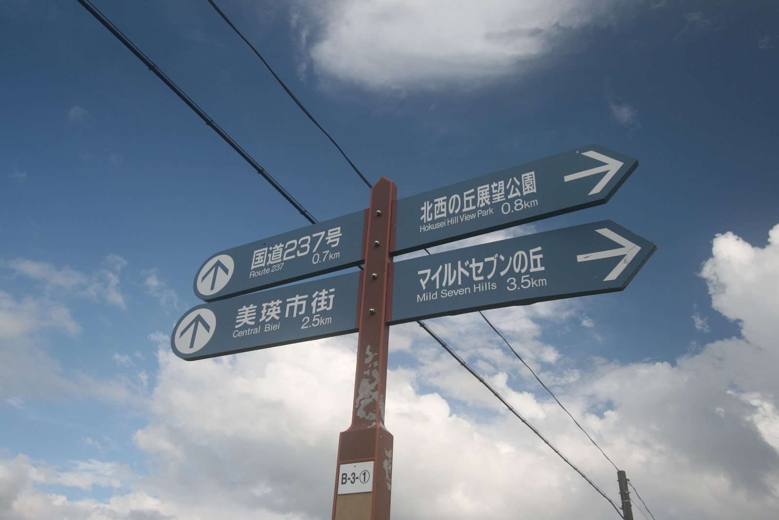
| Road sign at Biei |
 |
| Ken & Mary Tree |
Well they are trees and we may misinterpret the wrong tree. Our first stop was the Ken & Mary Tree. This is a giant poplar tree that became popular after the Nissan car maker commercial. We parked our car at an open space car park and walked over the road to take pictures. This is a Ken & Mary pension which you can booked for accommodation.
 |
| The Parent & Child Trees |
 |
| One of the roads |
We drove to the Panoramic Road and the
Patchwork Road to see the hills and fields. Again we just keyed into the GPS
and follow the directions. Next we drove to see the Oyaku tree (Parent and
Child Tree). From a distance you can see 2 adults "holding" the child
between them. These trees are Emperor oak trees.
 |
| The Philosophy Tree |
Then we visited the Philosophy Tree along the Panorama Road, the way the tree arches when view from certain direction resembles of the thinker statue.
 |
| Mild Seven Trees |
Next we proceeded to the Mild Seven Trees, the one that the cigarette brand "MILD SEVEN" commercial used back in the 80s. These are Larch trees which stand together to form a natural wall against the wind to protect the crops. In case if you don't drive, some tourists rent bicycles to cycle around these hills to enjoy the views. After visiting these trees, time was not on our side as the sun began to set and it was a short drive back to our hotel at Biei station.
 |
| Sunset with the Philosophy Tree |
Day 4: Leaving Biel for Otaru.
 |
| Outside our hotel Lavenir |
Today we had the best weather, the skies were clear and the sun was shining. We enjoyed our breakfast before checking out. Kind of sad to leave this place when the weather turned sunny but we had other places to cover like Furano.
 |
| The Blue Pond |
Today we planned to visit the Blue Pond (青い池, Aoiike) near Biei as mentioned in the tourist brochures. The turquoise blue pond is about 18km away from Biei and driving took us about 30mins as there were speed limits for the drive from town. We took the route 966 from the town centre and drove all the way to the Blue Pond. There is a free parking space near the Blue Pond and a short 15mins walk brought us to the pond itself. Why it was blue? It was mentioned at the information board that there about some eruption of Mount Tokachi back in 1989 that the authority built some structure to prevent damage to Biei. The blue colour is due to some minerals dissolved together with the hot spring water. There was nothing to do there but to enjoy the pond itself.
 |
| The path to the Blue Pond |
The morning walk was quite pleasant after days of rains and cloudy skies. We drove to the nearby hot spring town of Shirogane Onsen and did some short exploration. There is a steel bridge that span across a deep ravine where a raging river flows. From there is a mountain road that leads to Kamifurano and Tokachidake Observatory. This mountain road is closed in winter and is also named as route 966.
 |
| The Tokachidake Observatory |
 |
| Start of the hiking trsil |
After a short drive we reached the Tokachi viewpoint. There were many cars here for a sunny summer morning with groups of hikers starting off their climb to the nearby mountain peaks. Would like to do this hike as well, but since we didn't plan for and need to reach Otaru by night. Since we were on our way to Furano and near Tomita Farm, we decided to make another stop at the farm to get some lavender ice-cream again. With the sun all out to play, everything
started to look beautiful. Prior to reaching Farm Tomita, a big field of
sunflowers caught our eyes near Kamifurano and we just stopped by the roadside
to take some shots.
 |
| Field of Sunflowers |
 |
| Along the road at Kamifurano |
There is this pension called Woody Life which has a field
of sunflowers near it. We did consider staying there for our 3 nights initially
but in the end chose Biei as our base. From there, it was just a short drive to
Farm Tomita. We also drove to another Farm Tomita just 1km away and decided to
have our lunch there. It was real warm under the hot sun, but find any shade
and you will feel cool.
 |
| The farm on a sunny day |
 |
| Always get good weather when we are leaving |
 |
| Rows of Lavender (We came too early) |
After lunch we drove to the town of Furano.
Again something caught our eyes and we made a detour to a field of lavender
which led us to the Furano Wine Factory, which is actually a tourist outlet
where sale of everything made from grape can be found.
 |
| Goodies for sale (all grape related) |
 |
| Grape Flavor ice-cream & cheese cake |
This place is at
Shimizuyama, near the Gakuden train station. We were attracted to the cakes and
ice cream that the cafeteria offers. The place was surprising crowded with a
lot of tourists from cars and tour buses. While still exploring Furano, we
stumbled upon the Anpan Man Shop located at Rokugo, Furano. getting to this
location is quite difficult without own transport. The shop is 19km from JR furano station and can be costly hiring a
taxi which may take 20mins. Anpanman is a Japanese cartoon character and anpan actually
means red beans. The place has jam making sessions, and even an art gallery
just based on Anpanman.
 |
| Anpanman Shop & Art Gallery |
 |
| At the Cheese Factory at Furano |
Our last stop at Furano was the Cheese Factory which is
located 3.4km from the JR Furano station. The factory has a shuttle bus from
the station to the factory. There were sale of different types of cheese and
milk and ice-cream. There is pizza cafe at the factory which we had our early
dinner before the long drive to Otaru. Lotsa exhibits to see at the cheese
factory and it was good fun visiting.
It was about 5:30pm when we bid farewell to furano, taking the Ashibetsu National Highway 36 that leads north-west. We drove up the toll-paying Hokkaido Expressway that runs southwards towards Sapporo. We drove for about 2hours along the expressway and it was already night dark when we reached the Sapporo highway interchange where we took the right lane that heads towards Otaru. This stretch of the expressway is called the Sasson Expressway that runs along the coast all the way to Otaru. The expressway ended in the city of Otaru and we just followed the straight road on route 17 until we reached our hotel. Our accommodation for 2 nights was the Hotel Vibrant Otaru. Fortunately we managed to get the last parking space behind the hotel as the number of lots are limited.
 |
| The Famous Otaru Canal |
Finally we checked into our rooms at 9:30pm. The hotel used to a post office of colonial design and the experience was different from the rest of the commercial hotels. The walk to the famous Otaru canal was just 5 mins away. With just a steady hand (did not bring tripod along), we took some night shots of the famous canal. Guess the place will be more attractive in winter. We cross the canal onto the opposite side which was dotted with seafood restaurants and drinking places. We walked along the streets and was surprise that some tourist shops were still open. It was back to the hotel for the night's rest.


No comments :
Post a Comment