Having been to Hong Kong a few times in the past, I had
always wanted to do some climbing there knowing there are lots of hills in Hong
Kong esp in the laid back south western part of the island of Lantau Island.
Every time the plane lands at their international airport, it will be always
greeted by the nearby mountains of Lantau Island. For our last recent trip, we
scheduled some time out of the short trip to clear this to-do list of climbing
maybe some peaks on Lantau Island. For the climb we picked the Sunset Peak (大东山, 869m) and the Lantau Peak (鳳皇山, 934m)which are both located on the same Lantau
Island and actually on the same island and just next to each other separated by
a mountain pass serviced by a road with a bus stop for climbers to have a
nearer start to the peaks. This little bus stop sits on the roadside like the
saddle of the mountain cutting across these 2 highest peaks of Lantau Island.
Climbing each of them will give you a close and majestic view of the opposite
mountain peak watching over you.
Getting to the trailhead is easy with Hong Kong's efficient
public transport network. From any part of
Hong Kong, just hop onto the orange line MTR which is called the Tung
Chung Line. Take the train and alight at the terminus of the orange line at the Tung Chung Station.
From there, follow the sign to to Ngong Ping Cable Car station where lotsa visitors will make their way for the
expensive and long queue to take the cable car up to the touristy village of
Ngong Ping to see the big bronze Budhha. The cable car is worth a one time
experience as it spans across the sea and climbing over the hills overlooking
the airport runway in the near distant. Do not take the escalator near the bus
interchange to cross the overhead bridge which is where the queue to the cable
car station is. Instead, stay on ground and cross the road at the traffic light
junction. To the right side of the cable car station, there is where the New
Lantau Bus Terminal is. This is the place where you can opt for the cheaper
transport to get to the touristy village of Ngong Ping. At times when the cable car is having
maintenance, you will find a long queue waiting for the bus.
 |
| Pak Kung Au ( In chinese characters) |
 |
| Entry point to the Sunset Peak Trail (Photo taken from bus stop) |
The place to go to for the trailhead of the climb is called,
Pak Kun Au (伯公坳)where there is a bus stop for the New Lantau Bus Services
ply. At the bus terminal at Tung Chung, there are a few buses that pass by this
location. Bus service 3M, 11 & 23 will pass by the Pak Kun Au bus
stop. For the bus fare, I would suggest
climbers to top up their octopus travel card for the bus fare. Sometimes the
drivers are always not in a mood to explain and talk to, so prepare you card
and just tap the reader when boarding the bus.
You can visit the bus service website for detailed bus routes and the
fare. The journey is quite short and in a few minutes time, the bus will be
climbing up the hilly road to this mountain pass of Pak Kun Au. Look for the
led sign board on the bus and the automated announcement inside the bus for the
next approaching bus station name. At times the bus can be crowded, so do make
your way earlier to the front of the bus to alight. Do press the bell once and make sure is
audible.
 |
| Signage for Sunset Peak near the bus stop |
Once you alighted at the bus stop at Pak Kun Au, you have a
choice to pick which nearby peak to climb. Sunset Peak to the east, or Lantau
Peak to the west. This bus stop is smack right in the middle of the island with
the road splitting the island into two.
In our case, we started off late and reached the Pak Kun Au
bus stop around 10:30am. Our intention was to cover both peaks in a single day
but as we started off late and with the super warm sunny weather at around 34
degree Celsius, our water supply ran low and with our pace we only managed to
clear Sunset Peak. And knowing we would not be scaling Lantau Peak on the same
day, we took out time to enjoy the mountain view before making our relaxing
walk ( still very warm) back to the same Pak Kun Au bus stop around 2:30pm. We did manage to return to the same start point
the next day to hike up to Lantau peak and fortunately the weather was kind to
us with cloudy skies (no rain) for the morning climb to the summit. Only when
we reached the summit did the clouds clear and out came the sun bringing all
the sunny weather to climbers up there.
Doing the Climb: Day
1 Sunset Peak (大东山)
 |
| Trailhead of the trail to Sunset Peak |
 |
| Signage for both Lantau Peak & Sunset Peak |
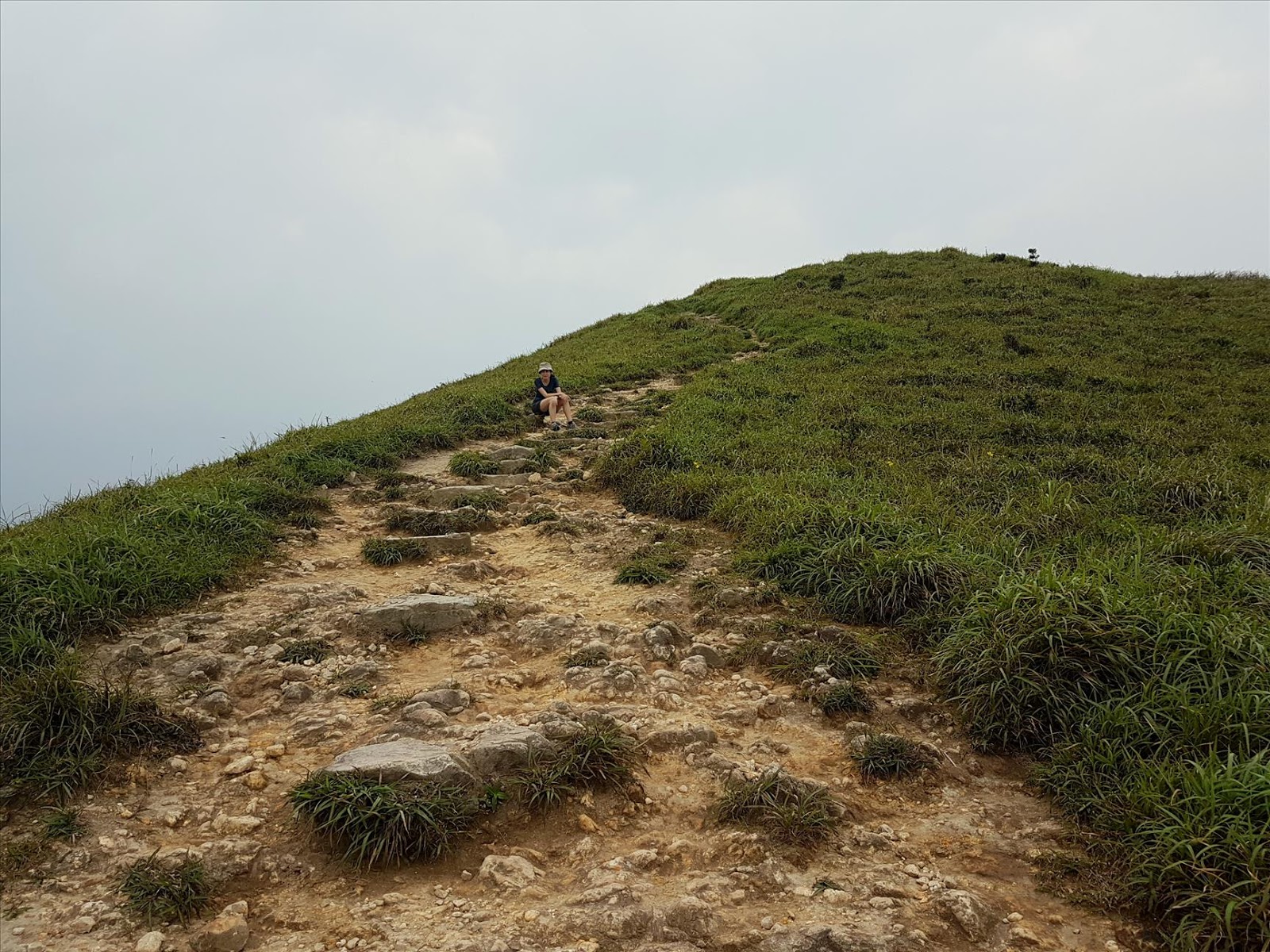
There we were at the Pak Kun Au bus stop, it is a choice of east or west,
both requires an estimate of 2 hrs to reach the summit. For out 1st day climb
was to Sunset Peak. On the same side when we alight from the bus that came from
Tung Chung, a small stairway leads up to a rest pavilion which marks the trail
head. The initial part of the climb is all about steps. There are big nicely
placed rocks that lined their way into the lower altitude forest area. Weather
was warm and we could only take some comfort away from the sweltering heat by
resting under the limited tree cover we could find.
There weren't much big trees even at the lower levels of the
climb. From the trail head of about 330m, we made our way slowly meandering up
the rock path, walking on blocks and blocks of rock that bought us out of the
treeline and into the open spaces. As we climbed higher, we could get a great
view of the towering Lantua Peak behind us. Like a guardian watching down on us
as we made our way up the hilly paths.
 |
| Lantau Peak in the distant (we were on the Sunset peak trail) |
 |
| Bright & sunny & scorching rays (Trail to Sunset Peak) |
 |
| Cleared the treeline and view of the sea |
 |
| Looking back at the trail we came from |
 |
| Background view of Lantau Peak |
 |
| Me with Lantau Peak |
 |
| Open and bare, sunshine buffet (up & up) |
It was up and up and at times only have a short distance of
level ground and due to the unkind hot weather, we took quite a fair bit of
rest stops to drink some water and snack a little. It took about an hour into
the hike before we clear much of the forest and up the grassy hills with the
sea to our right. At this time, we had unblocked view of the sea, the coastline
and the little villages of Shek Pik & Mui-Wo in the near distance. And of
course the Lantau peak. Along the way
up, many times we stopped to admire the tall Lantau Peak behind us and on this
clear and warm day, we could see clearly the trail leading up to the summit. It
seemed to be a tough and long climb but as indicated at the trailhead, the
climb to Lantau peak is still the same 2.5 hrs from the Pak Kun Au bus stop.
 |
| Background of the village of Mui-Wo |
 |
| Look positive for the climb ahead |
 |
| The trail behind |
 |
| Little stone huts scattered over the hills |
 |
| Sunset Peak |
 |
| Sunset Peak (aka Great Eastern Mountain) |
 |
| View of Lantau Peak from Sunset Peak |
 |
| Cigarette style summit marker |
 |
| Sunset Peak looking towards the islands |
There wasn't much other trail to get lost and it was just a
single trail and we just follow until we reach a big open plateau area which has
many stone cottages decorating the hills. At this point there are many trails
but just no sign board indicating which way to Sunset Peak. Based on the timing
we should be near the summit but since the peaks at Lantau Island are around
the same altitude, it may not be easy to know which way. It was an assessment on the ground and
looking for the highest peak around us and we turn left while facing the bunch
of stone cottages, follow the dirt trail up higher and higher over the hill. And soon enough we saw in the
near distance the summit "cigarette" black and white marker. There
were some hikers rest at the summit point and we were very sure that is the
Sunset Peak which is our objective for the day.
At the Sunset Peak, we could see the Hong Kong Airport and
the developed town of Tung Chung below us. There were 2 local uncles taking a
break as well at the summit there. They hike all the way from Tung Chung town
to this Sunset Peak summit. Weather was great but too warm and umbrella was a
girl's best friend up there. Wind was good at times but not too strong. At this
point, it seemed that Lantau Peak is still much higher than where we are.
Actually their difference is about 100m only but with the distance, it does
look to be much higher. We rested about 20mins at the summit to enjoy our snack
lunch before taking the same trail back to the bus stop at Pak Kun Au for the
trip back to Tung Chnung to catch the MTR back to Kowloon for our late lunch of
Tim Sum.
 |
| On a rocky outcrop on our way down. |
 |
| Going back the same way we came |
 |
| Descending back to the Pak Kung Au bus stop |
Throughout the climb, something interesting about the
mountain trails at Lantau. It is all grassy all over the hills up there. And
there are many little short side trail to better viewpoint and rock outcropping
for that great photo shot that you have been looking for. Don't worry about
getting lost, just back trail to the main trail after you decided to explore
around. All the trails evenly lead to somewhere and many does lead you back to
the major roads or to the nearby village where you can easily catch a bus back
to Tung Chung, or to village town of Mui-Wo where you can catch a speedy ferry
all the way to Hong Kong Island.
Doing the Climb: Day
2 Lantau Peak (鳯凰山)
Today, we woke up
earlier to catch the early MTR all the way to Tung Chung station again for the
half day climb to Lantau Peak on Lantau Island. Being more prepared today than
the day before with abundance of water supply and cold drinks to boost the morale
of the climb. Weather forecast was always saying short thunderstorm but never
did we see any noticeable rainfall. So
it was the train and bus and alighting at the same bus stop that we did the day
before.
 |
| Trailhead at the Pak Kun Au bus stop to Lantau Peak |
 |
| Nice resting spot with good views |
 |
| More trails then steps (Town of Tung Chung to the mid-left) |
 |
| Sunset peak in a not so sunny day |
 |
| Gradual ascend but longer distance |
 |
| Looking back at the trail we covered from Pak Kun Au bus stop |
 |
| Another rest area with unblocked view |
 |
| Still long way to go ( but still all within 2 hrs) |
The climb up the initial part of the forested
trail has some stone steps but these were much more manageable than the Sunset
peak which has much higher steps between each rock stairs. For the Lantau
trail, it seemed much more easier as there were gentle grounds for us to catch
our breath and rest the legs. Distance may be slight further but it was
definitely much more enjoyable than the day before. Maybe it was also because
of the weather. It was cloudy skies with
light breeze. The absence of direct sunshine was a reprieve from the scorching
sun the day before.
 |
| Time for a short break |
 |
| Off we go climbing higher |
 |
| The sun is coming out |
 |
| Almost reaching the summit |
 |
| Sunset peak in light mist or pollution? |
 |
| Lantau Peak within reach |
 |
| Just a few more steps |
And so we made our
way slowly up the trail towards the summit. There were 3 smaller peaks to cover
before reaching the summit. Once we cleared the short forest treeline, it was
unblocked view of the surroundings. And of course now the Sunset Peak behind
us. Maybe we started early as there was
no other groups on the trail. At times some local cross country trail runners would
sneak up behind us and run ahead. Guess these are the local that is using the
this Lantau trail for training. I would say this is indeed a convenient and
good place to trail for any demanding sports. Quite amazed that in a crowded
city of Hong Kong, they still retain a big part of the land for nature and
recreational for the citizens.
 |
| The rock that indicates where the summit is. |
 |
| Lantau Peak just behind me in a few steps |
 |
| The Lantau Peak summit (not so crowded for now) |
 |
| Summit signage |
 |
| Puff puff cigarette marker |
 |
| Stone shelter for hikers |
 |
| Crowd coming in and all sorts of pose on display |
 |
| Doesn't seems to have much effect on some hikers |
 |
| Both ways to descend |
After clearing the
3 smaller peaks, we reached the summit of Lantau Peak. The highest point on
Lantau Island, and 2nd highest peak in Hong Kong. The highest mountain peak is
Tai-mo Shan (Mt Tai-Mo), meaning "Big Hat", located in the mainland
part of Kowloon. Highest point housed a military radar station and so off
limits to hikers and so may not be that attractive to climb. Besides there are
public transport to get to close to the highest accessible point. So i think
Lantau Peak seems to be more of a mountain for the hiking enthusiast to visit.
At the summit,
there is a stone shelter for hikers to rest in case of extreme bad weather but
sadly it was filled with litter making it unpleasant to stay inside. I guess climbers visiting the peak need to be
more socially responsible and better educate to protect nature. And the
signboard at the shelter reminded hikers not to sit or climb onto the top of
the shelter which looks like some zinc or aluminum top. Yet we saw the locals aunties and uncles
climbing and standing on top to pose for their friends to snap photos at them.
At this time, the
sun has woke up and cutting through the clouds and evenly broke all the clouds
above. At the same time, more and more climbers had reached the summit and the
quiet, peace and tranquil that we were enjoying had been loudly disrupted by
loud music played off the climbers individual bluetooth speakers. With this, it
was time to make our descend.
We continued on from Lantau peak for our descend heading in the direction to the Big Buddha at Ngong Ping. Along the way, more and more human traffic were coming up from that direction. It was a tough climb from Ngong Ping as it is all the way steps and steps from the low altitude of around 400m all the way to the peak of 934m. It was easily a short ascend of 600m in mere 2hrs. It took us about 2hrs with some rest stops to get from Pak Kung Au to Lantua Peak, and the signboard from Lantau Peak to Ngong Ping was stated 45 mins at 1.5km. I think is took us longer than that. Maybe it is for those strong knees folks that could stand the constant landing of the feet on the hard rock steps for the descend. The weather turning real warm in similarity to the weather we had the day before.
 |
| Descending along the ridgeline of the mountain |
 |
| Great view of the sea to the left and the big buddha to the right |
 |
| Umbrella time. |
 |
| Lantau Peak (view from the Ngong Ping trail for climbers coming from there) |
 |
| Like the spine of a dragon leading out to see. |
 |
| Hard work for the pioneers that built this trail with rock steps |
 |
| Well thought of railing hikers |
 |
| Unmark trail to the left that leads down to the Shek Pik reservoir. |
 |
| Steps and more steps down. No more flat trail |
 |
| Steps and steps |
 |
| Nearing the Ngong Ping village route trailhead to Lantau Peak |
 |
| The Wisdom Path |
 |
| At the trailhead (and here comes the tourists) |
 |
| Buddha teachings |
 |
| Closer view of the wooden poles where buddhist mantra are inscribed on them |
 |
| At the open space of the heavens' altar |
 |
| Cool down time |
It took us about an
hour plus at a relax pace to reach the Wisdom Path attraction which is also the
trail head start point to Lantau Peak from the Ngong Ping route. When we reached
the Tori gate like those in Japan just this is the oriental version, we know we
were back in civilization. Hordes of tourists were visiting the Wisdom Path
attraction. For us, as we have been there just less than a year back, a quick
photo taking and off we joined the tourists on the concrete path back to the Ngong
Ping village. More tourists. In celebration of our climb to the summit, we
rewarded ourselves with ice-cream from one of the many souvenir shops that is
near the entrance to the Big Buddha.
 |
| Close up view of the Big Buddha (Photo taken in Dec-2016 trip) |
From here, we
queued for the bus 23 to take us back to the Tung Chung MTR station. You can
also either take the higher fare taxi or the more expensive cable car ride
across the hills and crossing the sea to the cable car station at Tung Chung.
Did that before and so prefer to save the money for tim sum.
Hope the writeup on
climbing Sunset Peak and Lantau Peak can help you plan for your climb the next time
you are in Hong Kong and wanted to experience some outdoor adventure and have a great workout
away from the noise and bustling streets of a metropolitan city.


4 comments :
If you can only hike one of Lantau peak and sunset peak, which one would you recommend?
Hi,
I would suggest Lantau peak as you can get to end near the big buddha for the bus ride or cable car down. Sunset peak is closer to the sea and can descend to MuiWo for the speed ferry back to Hong Kong island. Lantau Peak would be more popular and so you will get to meet more people.
Hi, would you suggest traveler to stay a night at ngong ping to catch sunrise view on Lantau peak?
Hi,
cant commend on that as i did not do that. if u need to go up to lantau peak to see sunrise, just need to arrange transport to bring you to the trail head and start the climb in darkness to get to the peak for the sunrise. If you read from other materials on the i internet, those usually stay at ngongping youth hostel over the night for the early morning climb.
Post a Comment